Sailplane Pilot Licence
Demo: SPL
Real exam questions to try for free — no registration needed.
During flight a problem occurs which you must solve; how do you proceed?
Show solution
The correct answer is to keep flying and stabilizing the aircraft first, then solve the problem while continuing to fly. The other options are wrong because flying always has priority; you must not neglect control to solve problems or ignore them.
What is the gas composition of "air"?
Show solution
Dry air is about 78% nitrogen, 21% oxygen, and 1% noble gases/carbon dioxide. The other answers are incorrect because they swap nitrogen and oxygen or wrongly list water vapor as a main component.
What is the mean height of the tropopause according to ISA (ICAO Standard Atmosphere)?
Show solution
The mean height of the tropopause according to ISA is 11,000 m. 11,000 ft and 18,000 ft are too low, and 36,000 m is much too high. The standard atmosphere defines 11,000 m as the average tropopause height.
Which unit is used for temperatures given by meteorological aviation services in Europe and Africa?
Show solution
The correct answer is Degrees Centigrade (°C), as temperatures in aviation meteorology in Europe and Africa are always given in Celsius. Kelvin and Fahrenheit are not used, and Gpdam is not a temperature unit.
The temperature lapse rate with increasing height within the troposphere according ISA is...
Show solution
The correct answer is 0.65°C per 100 m, as this is the standard lapse rate in the troposphere according to ISA. 3°C, 0.6°C, and 1°C per 100 m are either too high or too low and do not match the standard value.
What is the ISA standard pressure at FL 180 (5500 m)?
Show solution
The correct answer is 500 hPa, as the standard pressure at FL 180 according to ISA is about 500 hPa. 1013.25 hPa is sea level pressure, 250 hPa and 300 hPa are for much higher flight levels.
The altimeter can be checked on the ground by setting...
Show solution
Correct: Set QNH and compare the indication with the airfield elevation. QNH gives elevation above sea level. QNE uses standard pressure, QFE shows height above the airfield, and QFF is not used for this check.
Above the friction layer, with a prevailing pressure gradient, the wind direction is...
Show solution
Above the friction layer, wind blows parallel to the isobars because friction is minimal. The other options are incorrect: wind is not perpendicular to isobars or isohypses, nor does it blow at a 30° angle to the isobars, but parallel.
Which of the stated surfaces will reduce the wind speed most due to ground friction?
Show solution
Mountainous areas with vegetation reduce wind speed the most because both terrain and plants increase friction. Flat land with vegetation, deserts, and oceans offer less resistance as they have fewer obstacles for the wind.
When air masses meet each other head on, how is this referred to and what air movements will follow?
Show solution
When air masses meet head on, this is called convergence, which causes air to rise. The other options are incorrect because divergence means air spreads apart, and sinking air is linked to divergence, not convergence.
What are the air masses that Central Europe is mainly influenced by?
Show solution
Central Europe is mainly influenced by polar cold air and tropical warm air, as these air masses shape the climate. Arctic, equatorial, or only tropical air masses rarely or never reach Central Europe.
With regard to global circulation within the atmosphere, where does polar cold air meets subtropical warm air?
Show solution
Polar cold air meets subtropical warm air at the polar front. The other options are incorrect because these air masses do not meet at the geographic poles, the equator, or the subtropical high pressure belt.
"Foehn" conditions usually develop with...
Show solution
Foehn develops when stable air is widely blown against a mountain ridge. The air rises, cools, loses moisture, and descends warm and dry. The other options are incorrect because they mention instability or lack of airflow, which do not create Foehn.
Light turbulence always has to be expected...
Show solution
Light turbulence is expected below cumulus clouds due to rising warm air (thermal convection). Above cumulus clouds, air is calmer. Inversions and stratiform clouds in medium layers usually do not cause such turbulence.
Moderate to severe turbulence has to be expected...
Show solution
Moderate to severe turbulence occurs on the lee side of a mountain range when rotor clouds are present, as strong air currents form there. The windward side, low stratus clouds, or unbroken cloud layers usually do not cause such turbulence.
Which answer contains every state of water found in the atmosphere?
Show solution
Water exists in the atmosphere as liquid (rain), solid (snow, hail), and gaseous (water vapor). The other answers miss at least one state, so only 'liquid, solid, and gaseous' is correct.
How do spread and relative humidity change with increasing temperature?
Show solution
As temperature increases, the spread (difference between temperature and dew point) increases because temperature rises faster than dew point. Relative humidity decreases since warmer air can hold more moisture, but the actual water vapor stays the same.
The "spread" is defined as...
Show solution
The 'spread' is the difference between actual temperature and dew point. It indicates how close the air is to saturation. The other options describe ratios, other differences, or the maximum water vapor, which are incorrect.
The saturated adiabatic lapse rate is...
Show solution
The saturated adiabatic lapse rate is lower than the dry adiabatic lapse rate because condensation releases heat, slowing the cooling. The other options are incorrect: it is never equal to, proportional to, or higher than the dry adiabatic lapse rate.
The dry adiabatic lapse rate has a value of...
Show solution
The correct answer is 1.0°C/100 m, as dry air cools by 1°C per 100 m ascent. 0.65°C/100 m and 0.6°C/100 m are for moist air. 2°C/1000 ft is an approximation, but not exact for the dry adiabatic lapse rate.
Clouds are basically distinguished by what types?
Show solution
The correct answer is 'Cumulus and stratiform clouds' because clouds are basically classified as cumulus (heap) and stratus (layer) types. 'Thunderstorm and shower clouds' and 'stratiform and ice clouds' are special or incomplete categories. 'Layered and lifted clouds' is not a standard classification.
What condition may prevent the formation of "radiation fog"?
Show solution
Overcast cloud cover prevents radiation fog because it blocks heat loss from the ground at night. The ground doesn't cool enough for fog to form. The other conditions actually favor fog by allowing more cooling or moisture.
How is an air mass described when moving to Central Europe via the Russian continent during winter?
Show solution
Continental polar air is correct because it comes from the cold, dry Russian landmass in winter. Maritime air masses come from the sea, tropical air from warmer regions. Only continental polar air matches cold, dry winter air from Russia.
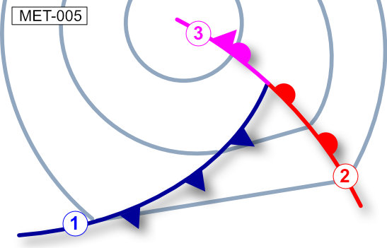
The symbol labeled (2) as shown in the picture is a / an... See figure (MET-005)
Show solution
The symbol with a line and semicircles represents a warm front. The others are: front aloft (not standard), occlusion (semicircles and triangles), and cold front (line with triangles). Only the warm front uses only semicircles.
What visual flight conditions can be expected after the passage of a cold front?
Show solution
After a cold front, visibility usually improves. Cumulus clouds with rain or snow showers form. The other options describe conditions typical before or during the front, such as poor visibility, stratus clouds, or prolonged precipitation.